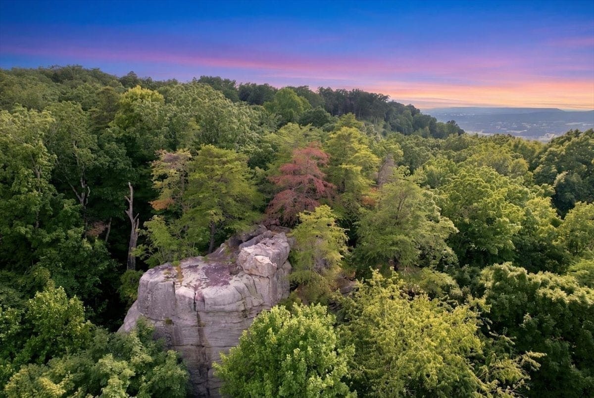
Lot 55 · The Bluffs at Rocky Ridge · Sparta, Tennessee
High Rock at The Bluffs
8.25 wooded acres on a hardwood ridge, holding the sandstone formation known locally as High Rock.
$189,900
Presented directly by the owner · Buyer agents welcome
Drone Tour
See the whole parcel in 83 seconds
The ridge, the rock, the long-range views and the graveled access — filmed from the air.
An aerial tour of the parcel: the High Rock formation, the long-range valley views, the ridge setting, and the existing gravel access.
Overview
The ridge, and what sits on it
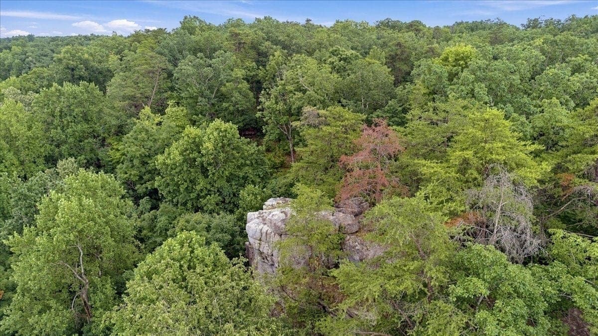
Lot 55 occupies a hardwood ridge inside The Bluffs at Rocky Ridge, and it holds something no other lot in the subdivision does: the exposed sandstone outcrop known locally as High Rock. The formation lies within the parcel boundary.
From the upper ridge the land opens across forest, valley and successive ridgelines. Roughly one to two acres sit along the bluff itself; the remainder falls away below it, wooded and steep in places.
Access already exists. Crestview Ln, a gravel common-access driveway shared with five neighbouring lots, runs from Coal Bank Road to the parcel. Electric, public water, natural gas and fiber are reported available to the subdivision, though none is connected here.
Septic has not been evaluated. There is no perc test, no soil report and no system design, and no capacity is represented. For most buyers that is the first piece of work, and it is the one variable that most affects what can be built.
- The formation
- High Rock lies within Lot 55
- The outlook
- Long-range ridge and valley
- Access
- Existing gravel shared drive
- Permitted use
- Single-family residential
The defining feature of Lot 55
High Rock lies within this parcel
The exposed sandstone outcrop known locally as High Rock sits on Lot 55, and on no other lot in The Bluffs at Rocky Ridge. It rises from the hardwood ridge and holds the last light of the day.
It is a local name of long standing, not a designated or protected landmark. The bluff edge, the rock surfaces and the elevation change around it are genuine hazards — anyone walking the property should read the visiting notes first.

- 8.25
- Acres
- $189,900
- Price
- $23,018
- Per acre
- None
- HOA
- Recorded
- Covenants
- Gravel
- Shared access
- Required
- Septic
- $564
- 2025 taxes
Gallery
From the air, the ridge and the rock
Showing 10 photos.
High Rock catching the last light above the valley.
Sunset from a vantage point of High Rock.
Morning fog settling across the valley below.
High Rock in the foreground, with the valley and farmland beyond.
Twilight settling across the ridges beyond High Rock.
A closer view of the sandstone formation.
Long-range valley and ridge views from the bluff.
Open hardwood understory with room to walk and explore.
Crestview Ln reaches the property, with the valley visible beyond.
The gravel utility pad shown is on neighboring Lot 54.
Crestview Ln marks the entrance to the shared gravel driveway.
Property-line overlays, maps, labels, and aerial annotations are approximate and for marketing purposes only. They are not surveys.
37 photographs in the full catalogue, with per-image notes on what belongs to neighbouring lots.
See all 37 photographsPlan Your Visit
How to find & tour the land
Because this is undeveloped land on a shared driveway, the street address may not resolve precisely in mapping apps. Please navigate using the GPS coordinates below.
Please visit respectfully.
Visitors enter the property and the common driveway at their own risk. Please visit during daylight, park along the shared driveway only where another vehicle can still pass, do not block access for neighboring lots, and do not enter neighboring property.
The A-frame residence visible in certain photographs is on neighboring Lot 57. The gravel utility pad visible in certain aerial photographs is on neighboring Lot 54.
The terrain is genuinely steep
This is undeveloped, wooded terrain. The bluff edge, exposed rock surfaces, loose ground, steep grades and significant elevation change present real hazards. Approximately one to two acres lie along the upper bluff; much of the remaining acreage falls below it. Climbing or standing on the High Rock formation is done entirely at the visitor's own risk.
Come in daylight
There is no lighting, no marked path and no cell coverage you should rely on. Give yourself time to walk out before dusk.
Park without blocking
There is room along the shared driveway to pull over and still let another vehicle pass. Six lots depend on that drive, so leave it clear.
Stay on Lot 55
Neighbouring lots are private. The A-frame residence and the gravel utility pad you can see from the ridge both belong to other owners.
A shared gate serves the driveway and is normally open. If it is closed, contact the owner for access instructions before visiting. Visitors enter the property and the common driveway at their own risk. Please visit during daylight, park along the shared driveway only where another vehicle can still pass, do not block access for neighboring lots, and do not enter neighboring property.
Property Details
The Facts, Clearly Stated
A polished summary followed by a complete, accessible list of the property facts. Buyers should independently verify all items.
Acreage
8.25 acres
Price
$189,900
Zoning
Residential
Type
Undeveloped land
Access
Graveled drive built
Wastewater
Septic required
HOA
No HOA
Covenants
Recorded
- Address
- 233 Crestview Ln, Sparta, TN 38583
- Parcel
- 038 001.55
- Subdivision
- The Bluffs at Rocky Ridge
- Lot
- 55
- Acreage
- 8.25 acres (per deed/survey)
- Zoning
- Residential
- Permitted primary use
- Single-family residential use, subject to recorded covenants and government requirements
- HOA
- None. No dues, no board, no architectural committee.
- Covenants
- Recorded restrictive covenants apply. They keep the subdivision residential and require tracts of at least five acres, which protects the surrounding density.
- Access
- Existing graveled shared driveway known as Crestview Ln, connecting to Coal Bank Road. Access is already constructed to the parcel.
- Wastewater
- Private septic system required
- Septic status
- No current written septic approval is being represented. Buyer must independently verify soil suitability, system design, bedroom capacity, permitting, and cost.
- 2024 property tax
- $740
- 2025 property tax
- $564
- 2026 property tax
- $564
- Price
- $189,900 (approx. $23,018/acre)
- Buyer-agent compensation
- 3%, subject to written agreement and accepted contract
Utilities
Who serves this ridge
Electric, public water, natural gas and fiber are reported available to the subdivision, and the gravel drive already reaches the parcel. None of it is connected to a building location, and septic has not been evaluated — those remain the buyer's work.
Electric, public water, natural gas and fiber service are reported available to the property or subdivision. No service is represented as connected to any building location on the parcel. Buyers should independently confirm service location, availability, capacity, current fees, extension requirements and installation costs directly with each provider.
Electric
Volunteer Energy Cooperative
235 O'Brien Drive, Crossville, TN 38555
(931) 484-3527- A $35 purchaser fee was previously reported.
- A standard allowance of up to 750 feet of overhead or underground service was previously reported.
- Work beyond the standard allowance is job-specific.
- Underground trenching, conduit/pipe, and rock removal may create additional costs.
- Historical trenching estimates ranged from $5 to $25 per linear foot.
Historical developer-provided information — current terms must be confirmed with VEC.
Public Water
BonDeCroft Utility District
8756 Crossville Highway, Sparta, TN 38583
(931) 935-2150- A 3/4-inch water meter and connection fee of $1,350 was previously reported.
- Additional trenching, pipe, and rock-removal costs may apply.
- Historical trenching estimates ranged from $5 to $25 per linear foot.
Historical developer-provided information — current service availability, fees, meter location and installation requirements must be confirmed with BonDeCroft Utility District.
Covenants
No HOA, but the land is not unrestricted
There is no HOA, no board, no dues and no architectural committee. The property is, however, subject to recorded restrictive covenants. Below is a plain-language summary of the main provisions — the recorded instrument is the controlling document and should be read in full.
- Single-family residential use across the subdivision, not only this lot.
- Mobile homes are prohibited.
- Junk vehicles, abandoned vehicles, scrap, trash and debris are prohibited.
- Nuisance and annoyance activities are prohibited.
- Commercial drilling, mining, quarrying, refining and mineral development are prohibited.
- Home-office use is permitted where it creates no exterior sign, no additional traffic and no toxic storage.
- Utility easements are reserved across the subdivision.
- A tract may be subdivided once, and both resulting tracts must retain at least five acres.
How the covenants are enforced
Enforcement rights are held by the owners of lots in the subdivision, not by an association or by the seller. That means compliance depends on the owners choosing to act, and neither the seller nor this website can guarantee that any provision will be observed or enforced.
The five-acre minimum applies to Lot 55 as well. At 8.25 acres it cannot be divided into two tracts that each meet that minimum, so the property is not marketed as subdividable. Buyers and their legal counsel should review the recorded covenant in full before relying on any summary, including this one.
Access & Easements
Shared driveway & road access
Access is recorded and already in place. Here is exactly how you reach the parcel, what is shared with the neighbouring lots, and what that obliges an owner to do.
How you get there
The parcel is reached from Coal Bank Road via Crestview Ln, an existing gravel common-access driveway that already serves this part of the ridge. The drive runs to the parcel, so access does not have to be built from scratch. It is a private shared drive, not a public road, and it is not paved.
The details
- Surface
- Existing gravel
- Maintenance
- Shared among Lots 53–58
- Recorded agreement
- Recorded shared-driveway agreement
Due Diligence
The recorded documents
Tell the owner where to send them and the recorded documents arrive by email, along with a set of links you can open straight away.
Recorded Restrictive Covenants
Sent on requestThe complete recorded restrictive covenants for The Bluffs at Rocky Ridge.
Request this documentProperty Fact Sheet
Sent on requestA one-page summary of the parcel: size, price, access, utilities, taxes and the recorded restrictions.
Request this documentShared Driveway Agreement
Sent on requestThe recorded shared-driveway agreement covering Crestview Ln, setting out maintenance and cost allocation across the lots it serves.
Request this documentSurvey
Sent on requestThe complete recorded survey for The Bluffs at Rocky Ridge, with lot 55 highlighted.
Request this documentThis website is provided by the property owner for marketing and informational purposes. Information is believed to be accurate but is not guaranteed. Buyers and their representatives must independently verify acreage, boundaries, survey matters, access, zoning, covenants, utility availability, service locations, connection costs, soil suitability, septic capacity, permitting, taxes, insurance, financing, and suitability for any intended use.
Questions & Answers
What buyers should know before they visit
Including the limitations. Where something has not been established — septic, buildability, boundaries — this says so plainly rather than leaving you to find it at closing.
Where is the property located?
The property is at 233 Crestview Ln, Sparta, TN 38583, in The Bluffs at Rocky Ridge subdivision (Lot 55, parcel 038 001.55), in White County, Tennessee. Access is from Coal Bank Road via the graveled shared driveway known as Crestview Ln.
Why may the address not appear correctly in Google Maps or Apple Maps?
As undeveloped land on a shared driveway, the mailing address may not resolve precisely in mapping apps. Please navigate using the GPS coordinates provided in the Visit section rather than the street address. The access point is 35.967056, -85.366111.
Can I visit the property without an appointment?
Self-guided visits are welcome during daylight hours, but please contact the owner before you come. A shared gate serves the driveway and is normally open; if it is closed you will need access instructions. Visitors enter at their own risk, must not block the shared driveway, and must not enter neighboring property.
Where should I park?
Visitors may remain parked along the shared driveway only where they can do so safely and without blocking access. Do not block access to neighboring lots or residences, and do not enter neighboring property.
Is Crestview Ln paved?
No. Crestview Ln is currently an existing graveled common-access driveway. It is not a public road.
Is the shared driveway already constructed?
Yes. The graveled shared driveway already exists and connects to Coal Bank Road. It serves Lots 53 through 58 under a recorded shared-driveway agreement.
Is the A-frame located on Lot 55?
No. The A-frame residence is on neighboring Lot 57. It is shown in some photographs because it is visible from the ridge, and because it demonstrates that a custom residence has been built within this subdivision. It is not included with Lot 55, it is not on Lot 55, and it does not represent an approved plan, a permitted design, or any assurance that a similar residence could be built here.
What is the gravel pad visible in some aerial photographs?
That is a gravel utility area on neighboring Lot 54. Lot 55 begins beyond it.
What is the terrain actually like?
Approximately one to two acres lie along the upper bluff and ridge area; much of the remaining acreage falls below the bluff. The bluff edge, exposed rock surfaces, loose ground, steep grades and elevation change present real hazards. Visit during daylight, wear appropriate footwear, and treat climbing or standing on the High Rock formation as entirely at your own risk.
Is High Rock an official landmark?
No. High Rock is a long-standing local and historical name for the sandstone formation on Lot 55, and the parcel has previously been indexed publicly as 'Lot 55 High Rock @ the Bluffs'. It is not a designated, registered or protected landmark of any municipal, county, state or federal authority, and no such status is claimed.
Is there an HOA?
There is no HOA. However, the property is subject to recorded restrictive covenants and a recorded shared-driveway agreement, so it is not unrestricted.
Are there restrictive covenants?
Yes. Recorded restrictive covenants apply. They provide for single-family residential use and include various restrictions. Buyers and their legal counsel should review the recorded document in full.
Are mobile homes permitted?
No. The recorded covenants prohibit mobile homes. Refer to the recorded covenants for the complete and controlling language.
Can the property be subdivided?
The recorded covenant allows a tract to be subdivided no more than once, but both the parent tract and the newly created tract must each contain at least five acres after subdivision. Because Lot 55 contains 8.25 acres, it does not presently meet that requirement to create two five-acre tracts. The property is not marketed as subdividable; buyers and their legal counsel should review the recorded covenant independently.
Are electric, water, gas and fiber available?
Electric (Volunteer Energy Cooperative), public water (BonDeCroft Utility District), natural gas (Middle Tennessee Natural Gas), and fiber/TV (Ben Lomand Connect) are reported available to the property or subdivision. Buyers should independently confirm availability, capacity, fees, and installation costs with each provider.
Are utilities connected?
No. Utilities are reported available in the area or subdivision but are not represented as connected to any building location on the parcel. Connection location, fees and installation costs must be verified with each provider.
Does the property have sewer?
No. There is no public sewer. A private septic system is required.
Has the property been approved for septic?
No. There is no perc test, no soil report, no system design and no permit, and no bedroom capacity is being represented. Soil suitability and septic feasibility have not been established. Historical statements attributed to the developer about septic capacity are not documented and are not repeated here as a property claim. Buyers must independently verify soil suitability, system design, bedroom capacity, permitting and cost.
Is the property buildable?
No representation of buildability is made. The property is zoned residential and the recorded covenants provide for single-family residential use, but buildability depends on septic feasibility, site conditions, engineering, permitting and applicable government requirements — none of which has been established. A buyer should evaluate all of these before relying on any intended use.
Is seller financing available?
Seller financing may be considered for qualified buyers. Terms are subject to seller approval, written agreement, and applicable legal requirements.
What are the property taxes?
Reported property taxes were $740 for 2024 and $564 for 2025. Buyers should verify current tax amounts with the White County Trustee.
What is the parcel number?
The parcel number is 038 001.55.
Are property-line overlays surveys?
No. Property-line overlays, maps, labels and aerial annotations are approximate and for marketing purposes only. They are not surveys. Refer to the recorded survey for legal boundaries.
Is buyer-agent compensation offered?
Yes. The seller is offering 3% buyer-broker compensation at closing, subject to a separate written compensation agreement and an accepted purchase contract. Compensation is payable to the buyer's licensed brokerage.
How may a buyer submit an offer?
Interested buyers may contact the owner to express intent to submit an offer. The owner will coordinate the purchase contract and closing process. Buyer agents are welcome to submit on behalf of their clients.
Who verifies zoning, utilities, septic, boundaries and intended use?
The buyer and the buyer's representatives are responsible for independently verifying zoning, utility availability and costs, septic suitability and permitting, boundaries and survey matters, taxes, and suitability for any intended use.
Get In Touch
Speak to the owner directly
Ask the owner anything about the parcel, the covenants, the access or the terrain. There is no agent in the middle, and the recorded documents are sent as soon as each one is ready.
233 Crestview Ln, Sparta, TN 38583 · For Sale By Owner
For Real Estate Professionals
Buyer agents are welcome here
The seller values buyer representation and is offering competitive buyer-broker compensation, documented in writing, on a straightforward direct-to-owner transaction.
3% buyer-broker compensation
The seller is offering 3% buyer-broker compensation, payable at closing to the buyer's licensed brokerage, subject to a separate written compensation agreement and an accepted purchase contract.
Documented in writing
Register your buyer, execute a written compensation agreement, and submit offers directly to the owner. Nothing is left to a handshake.
Licensed agents welcome
This property is offered directly by the owner and welcomes licensed Tennessee buyer agents and their clients.
Buyer-broker compensation is subject to a separate written agreement and an accepted purchase contract. Broker compensation is not set by law and is fully negotiable.